
 The trail here is quite pretty with a long high ridge of peaks to our right. About 2 miles from town we came upon a parking lot and toilet. Moving on we came across another parking lot about 4 miles out that was for Lenice Lake. Both of these spots look good for camping. Much better than what we chose and the toilet would’ve been a nice addition to camp. Lesson learned there.
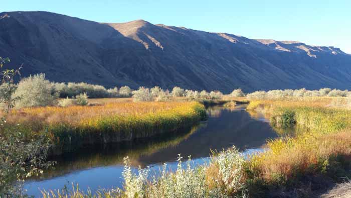
 This area is called Lower Crab Creek. It’s super pretty and full of ponds and swamps and streams. Great place to day ride out of or do a beginner bike pack trip. I also hear the Beverly Dunes area nearby but I’ve yet to look into that for fatbiking.


The only wet spot on the entire first 200 miles and Randy’s chain broke…right in ankle high mush lol….

A lot of gates were just like this. Easy to get around.
Traveling on, we arrived at the infamous “Smyrna” area. An old railway stop but not an actual town. This was where we’d be attacked by hundreds of goat head thorns. These things are serious. Hard as a rock and sharp as a razor. We had hundreds in each tire in just a few hundred feet of riding.

 Thankfully we were both running tubeless wheels and plenty of Stans liquid latex sealant. We didn’t flat thankfully. We were surrounded by millions of them and we came out victorious. Sparta!!!! There was a moment though when we both thought, man this is gonna be rough if we have to continue on the trail. But in Smyrna there is another detour. The start of a very long detour off the trail. Our version had more pavement in it though by accident.
It’s also here where we goofed up and misread our maps and ended up going the wrong way…for a long way haha. Instead of continuing east on Crab Creek Rd we took our turn up to Hwy 26, just like the DNR maps says (In their defense I just didn’t know how to read a map haha). This sent us through some farms and up over a small pass. The good was that we ended up at a Shell station full of hot fried food where we reloaded on chicken fingers and hot dogs and yup, more Gatorade. The downside was that we took Hwy 26 all the way to Othello which was a drag. It has a huge shoulder but still loud and just a drag. Don’t do what we did unless you need corn dogs BAD.

The super pretty view just before our big big map mistake. Seriously, this area is insanely pretty.

This is a section of the railroad that must have been some addition that ran north and still had the track on it but appeared abandoned. Oh, and if you see this cool bridge, turn around. You’ve gone too far!


Randy leading out up the pass. Off to our left you can’t see it but there is a stream there and we saw two different Herons hunting.


Taking a quick break before continuing on up the road. That semi up ahead was one of the contributors to “onion road” that you’ll read about.

Still climbing…selfie time

The only perk of our mistake…..chicken fingers and hotdogs lol

Riding up the road I was fighting some serious shifting issues and stopped a few times. Too tired to fuss with it I just kept on because Randy was really pulling away from me. Just before Othello he pulled over in a shady spot and when I l set my bike down I noticed a chain link was coming undone. Quickly fixed that and we were on our way again. Earlier, Randy had broke his chain so we were one for one 🙂


The night was quiet, cold and clear.
Totals:
- Beverly to Smyrna =14 miles
- Smyrna to Othello =27 mies
- Othello to Warden =15 miles
- Day Total: 56 miles and 9hrs of ride time including breaks
- (8am-6pm)
Follow along on the rest of the trip:
Read about Day 1 here, Day 2 here, Day 4 here

It’s easier to put this all together now after following your blue dot trail, day by day……….am really enjoying your blog………..well done
LikeLiked by 1 person
Yeah. I’m sure the blue dot thing was weird to watch. It’s fun to zoom into the satellite view though. But now maybe some of these names and spots will make a little more sense 🙂
LikeLike
Shawn, I just got into your blog tonight and I’m in for the long haul! Great stuff, man. Your documentation will be a major asset to others who are planning JWPT trips.
This particular section, from the Columbia to Warden, is adventurous as hell. I don’t think there is any way to ride this section for the first time, by whatever route, and not have an experience that will somehow stick with you for the rest of your life. It’s just rad, mean, gorgeous land.
As a humble supplement to this post, for anyone planning a trip through this area, HERE is a route that, while not perfect, takes in all of lower crab creek road, and also avoids onion road with what I think is a pretty special ride along the awesome irrigation canal network between Othello and Warden.
Super job Shawn and Randy! This trip is the real deal and no small feat.
LikeLike
Did you have trouble with getting tent stakes into the ground out there or did you use freestanding tent?
LikeLike
Wow you dug up an old one haha. Ground was very hard and we did have free standing tents but I think we just pounded them in with rocks nearby.
LikeLike
Thank you
LikeLike